The nexus between transportation and land use.

Category: Transport Modes Page 2 of 3

Bikes vs. Cars

We know who wins the battle – physically and generally as a matter of policy throughout the U.S.

I hesitate wading into this as it is not normally my area of expertise. Caveat: my professional focus is public transportation. And yet, I feel the need to weigh in because there has been some very good writing done recently on bike laws and infrastructure and I have my own recent personal and professional experience to bear.

I’ll start off by saying that I am an occasional bike rider who commutes mostly to work, to pick up the kids from school and other local trips. I also live in Chicago – a city known for its traffic as well as its aggressive expansion of bike infrastructure recently.

My neighborhood, Jefferson Park, has been in the middle of a fairly dramatic fight over a complete streets proposal for Milwaukee Avenue, one of the major road arteries through Chicago’s northwest side. Ostensibly, the proposal follows the City of Chicago’s Complete Streets guidelines which state clearly that:

The safety and convenience of all users of the transportation system including pedestrians, bicyclists, transit users, freight, and motor vehicle drivers shall be accommodated and balanced in all types of transportation and development projects and through all phases of a project so that even the most vulnerable – children, elderly, and persons with disabilities – can travel safely within the public right-of-way.

To adhere to this policy a pedestrian-first modal hierarchy of road users has been developed in which “all transportation projects and programs, from scoping to maintenance, will favor pedestrians first, then transit riders, cyclists, and automobiles.”

So why am I focused on the bottom two modes in the hierarchy? Because this is where much of the fighting over street use takes place.

In Jefferson Park, the complete streets proposal is to reallocate space on a 5-lane arterial road which sees annual average daily traffic counts between 15,000 and 19,000 vehicles. One potential idea is to reallocate space from this:

milwaukee-avenue


to this:

milwaukee-avenue-road-diet


Of course, the road diet cross-section does not show blocks where parallel parking will still be allowed nor does it show the potential for street bump-outs, pedestrian refuge islands, transit lanes, and other features of complete streets, all of which are being examined.

So you might imagine the public anger that has erupted from seeing such a proposal. Because traffic actually moves well (really!) in this corridor, people don’t want to change its existing conditions – which also include gross violations (due to engineering design) of the speed limit, typically in excess of 1.5 times the posted 30 MPH limit or the fact that there have been 1,000 vehicle crashes in this mile long corridor over the past 5 (five!) years alone. Clearly the road is working well. So the road diet brings the accusation that the City will “take” space for cars and “give” it to bicycles (which have an existing painted 5-foot lane). This is what is truly unacceptable to many people (drivers) because roads are for cars, right?

Which brings me back to the fight over street space and bicycle use of that space. Vox.com recently wrote about why cyclists should legally be allowed to roll through stop signs and red lights (which is illegal in Illinois as in many other states but also which is commonly ignored by both police and bicyclists). I won’t get into the physics about why bicyclists do this only to note that it pisses car drivers off to no end who want to see enforcement of the law (like speed enforcement, right). But, as Charles Marohn of Strong Towns, who has provided me with significant insights on urban planning, has stated:

Stop signs weren’t designed for cyclists. In fact, very little of our built environment was designed with cyclists in mind. What we have done – as I pointed out way back with the video on the diverging diamond – is developed a tolerance for cyclists, and that only with some heroic effort. Engineers now generally accept cyclists and have even created checklists to help us accommodate them – at least the skilled ones – at a minimal level in our current transportation system. Tolerating cyclists, and sometimes even attempting to accommodate them, is a far cry from designing systems based on their needs.

We need to rethink our urban areas. They need to be redesigned around a new set of values, one that doesn’t seek to accommodate bikers and pedestrians within an auto-dominated environment but instead does the opposite: accommodates automobiles in an environment dominated by people. It is people that create value. It is people that build wealth. It is in prioritizing their needs – whether on foot, on a bike or in a wheelchair – that we will begin to change the financial health of our cities and truly make them strong towns.

So my response to my neighbors in Jefferson Park is that as long as we continue to design Milwaukee Avenue for the benefit of drivers, our community will always lose. We will not get the economic development we seek, for who wants to walk down a 5-lane arterial road with cars blasting through at 45 MPH? And our bicyclists, along with our pedestrians and transit riders will lose.
The latest example proving the nexus between transportation and land use…

Crossrail Line 1. Source: David Arthur

…Comes to us from London, my brief one-time home. Courtesy of Crossrail, the major commuter rail project linking East and West London together more seamlessly with dramatic expected time savings. While Crossrail is not scheduled to open until 2018, the benefits that the Crossrail project is promising to deliver have already impacted the local real estate market.

Goldman’s employees would be able to reach Heathrow Airport from Farringdon in about 30 minutes on Crossrail, compared with more than an hour on the London Underground. Travel to east London’s Canary Wharf financial district will take 9 minutes, from about 25 minutes today. The City Thameslink system already takes passengers to Gatwick Airport to the south and Luton Airport north of the City.

“That’s what makes this the crossroads of central London,” Rees, the City’s top planner, said in an interview.

Crossrail will build 9 new stations in Central London, provide up to 24 trains per hour (1 train every two and a half minutes!) carrying 1,500 riders each. It will increase the rail network capacity while simultaneously reducing travel times by up to 50%. Transit-oriented development is already taking place, capitalizing on new areas of Central London becoming more accessible. More than 3 million square feet of residential and retail development are anticipated to take place, just over the stations sites.

This is the benefit that transportation infrastructure can bear on a place. It is smart development – taking advantage of the high-capacity, incredibly expensive infrastructure by also providing high density land uses to leverage that infrastructure investment.

See video.


Union Station

A public service announcement:

I’ve got a guest post up over at my friend Molly’s fantastic site talking about the history of Chicago’s Union Station.

The Great Hall at Chicago Union Station.

The Great Hall at Chicago Union Station.

Phoenix

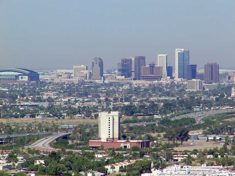
Phoenix. The Valley of the Sun. Soon to be home to my sister and her girlfriend. They’re moving at the end of the month to start the next phase of their lives together. I am sad, of course, and yet happy for them on this exciting adventure. I am no expert in Phoenix, having only visited the city once, but as an urban planner, I am adept at researching city data. So, here I present some interesting facts and observations about Phoenix from a planning perspective.

It’s Big!

Phoenix’s population is 1.469 million people. The city alone accounts for 22% of the State of Arizona’s population, making it the primate city in the state. It’s the 6th most populous city, behind New York, Los Angeles, Chicago, Houston and Philadelphia. It’s metropolitan area is home to two-thirds of all Arizonans. It’s footprint is gigantic as well. Lying in the Salt River Valley of the Sonoran Desert, Phoenix spreads out over 516 miles, more than twice the land area of Chicago. And for all that land, it’s not particularly dense, with only 2,800 people per square mile, or about a quarter of Chicago’s population per square mile. This kind of density is hard to support transit, but you might be surprised that one of the newest and most successful light rail lines was built in the city recently (more on that below).

Getting Around

Given the size of the urban area and the character of its urbanism (suburbanism), a car is essential for reasonable travel. Unfortunately, your visitors will be arriving via plane, as the last passenger rail service was suspended in 1996. Phoenix is the largest city without intercity passenger train service. However, visitors landing at Sky Harbor International Airport have the option of taking the train. The Metro light rail system, a 20 mile single line system serving 28 stations, opened in 2008. The line serves central Phoenix, Tempe and Mesa. Back to being big – Mesa, at almost 440,000 people, is the second largest suburb in the U.S., ranking above many major cities like Miami, Atlanta, and St. Louis.

Sky Harbor is the main Phoenix airport and has a Southwest hub, very important for travel back to Chicago. It’s the 10th busiest in terms of passenger traffic.

Roads are plentiful. The main interstates are 10 and 17. I-17 will take you to Sedona in 2 hours, Flagstaff in 2 and a half. I-10 will take you to L.A. in 7 hours or so. As a Chicagoan, I was struck by the size of the arterial roads in the Phoenix area. Six lanes with a double left turn lane are common. It’s no wonder everyone drives.

Similarities to Chicago

Not many as you might expect. But the obvious ones are sports related. The Chicago Cubs have the spring training home in Mesa, attracting a lot of Chicagoans to visit and retire. Also, not to be forgotten, is the fact that the Arizona Cardinals used to be the Chicago Cardinals until 1960. I also think Phoenix’s dominance as Arizona’s primate city and capital is somewhat similar to Chicago. And the prevalance of the cardinal direction street grid is familiar to Chicagoans.


Like all cities, Phoenix is fascinating and has an interesting story. From my perspective as an urban planner, particularly in the transportation realm, I am fascinated by the urban form of the region, how transportation or natural (or political) boundaries enforce the geography of a place. Phoenix has more stories to tell.

Cross posted at Ryan J. Richter.

Building Skyscrapers Over Trains

I came across this instructional video on the same day that I saw that the River Point development off of Canal St. and Lake St. in Chicago has broken ground. This project is being constructed above the Metra tracks leading into Union Station (H/T Atlantic Cities).

Page 2 of 3

Powered by WordPress & Theme by Anders Norén